


|
|

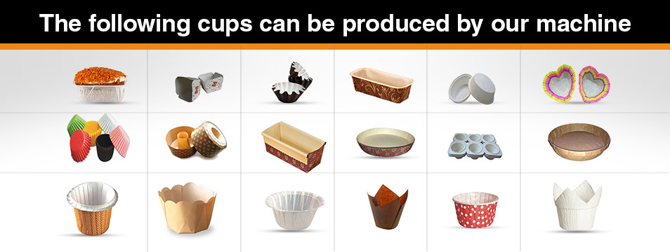
 Muffin Cup Machine
|
Name: Kevin Luo |


Guizhou Topography |
| Author : Date : 2013-12-20 16:44:45 |
Topography
Guizhou Plateau in southwest China landforms are mountains , the territory lying west to east , from the middle of the north , east and south side tilt , with an average elevation of about 1100 meters . Mostly mountainous Guizhou Plateau , known as the " Eight mountains of water a field ," said. The province's topography can be summarized into : plateaus, mountains , hills and basins are four basic types , of which 92.5% of the area is mountainous and hilly . Territory of the many mountains , mountainous , rolling horizon, high mountains and deep valleys . Big Lou northern mountains , diagonally across from the west to the northeast Northern Territory , 1444 meters high Chuanqian strategic pass Loushanguan ; central and southern lie Miao , 2178 m high mountain peak Thunder ; northeast border has Wuling Mountain , by the winds into Guizhou , Hunan , peak Fanjingshan high 2572 m ; west towering Wumengshan , is this mountain Pearl City Hezhang County Township Jiucaiping 2900.6 meters above sea level , is the highest point in Guizhou . The Southeast states Liping County Tsubosato river outlet at the provincial boundary , is 147.8 meters above sea level , the lowest point of the territory . Karst landforms are very typical. Karst area of ​​109,084 square kilometers , accounting for 61.9% of the province's total land area , the distribution of a wide range of karst territory , complete morphological types , geographical distribution obviously constitute a special karst ecosystem . |
